5G network supporting precision farming
An experiment conducted by the University of Basilicata tested the new mobile phone systems on agricultural work and the maintenance of green areas, highlighting the advantages of the system's great speed and precision
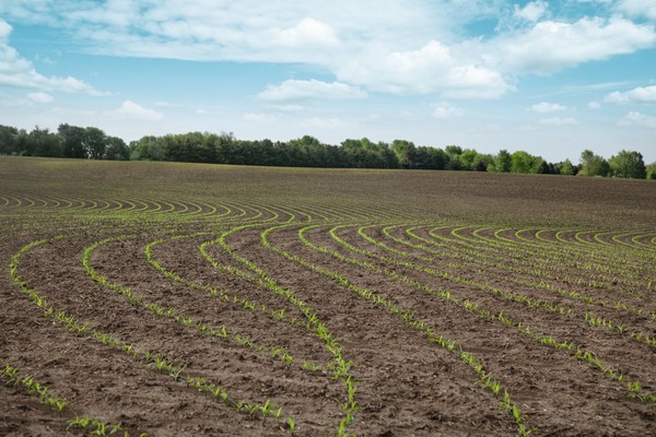
5G is the mobile telephony standard that will soon become part of our everyday lives, influencing our lives both directly and indirectly. The fifth generation of mobile radio systems represents the pinnacle of technological development in this sector, following research and experimentation lasting more than 30 years. With 5G systems, in addition to an exponential increase in download and upload speeds (20Gbit/s and 10Gbit/s respectively), it will be possible to record extremely low latency, incredible energy efficiency and the possibility of using the network even in high-speed mobile conditions. It is precisely the extremely low latency times that will make it possible to exploit 5G connectivity in various sectors, including agriculture, which is increasingly demanding in terms of 'lots of data in real time'. The aims of this work are linked to the efficient and effective management of agro-ecosystems and monumental green areas through the creation of an integrated agricultural management system based on: optimisation of water and fertiliser resources: through the implementation and use of variable rate prescription maps; the use of vehicles equipped with the latest generation of autonomous driving systems; reports and alerts on green areas of historical and artistic interest.
The partners identified in the project are TIM, Fastweb, POLIBA, UNIBAS, CNR, ALSIA, Digimat and Silos Granari. In order to carry out the experimentation, a study area has been identified in La Martella, an ancient village of rural tradition adjacent to the city of Matera (Basilicata). The area in question covers 5 hectares for the cultivation of Triticum Durum. The operational methodology involved the use of a multispectral camera mounted on a drone equipped with GPS with RTK correction; the frames thus acquired were first transferred to a raspberry via eth and then transmitted via ftp to a dedicated server. At this point, the geo-referenced images were radiometrically and geometrically corrected and mosaicked; the study area was extracted from the mosaic in order to proceed with image analysis.
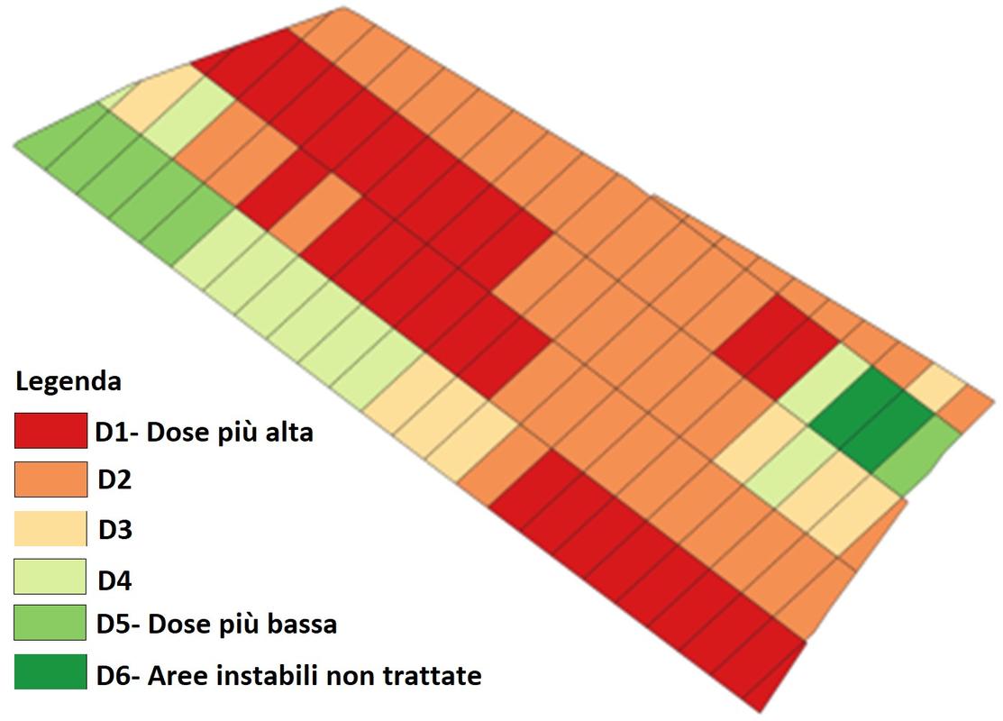
The result of the analyses, carried out with the aid of a specific algorithm developed by us, was a prescription map for variable rate fertilisation, which was subsequently loaded onto the on-board PC of the agricultural machine in order to spread the product in the field. Naturally, the spreading machine was equipped with an autonomous driving and navigation system with RTK correction, in order to minimise the corecording error between the image acquired by the drone and its positioning in the field performed by the machine.
The calculation of prescription maps, as the reader might have guessed, is a complex process that, in order to be really reliable, requires the use of: geo-referenced data, i.e. remote sensing images (UAVs, aircraft, satellites, etc.), agro-meteorological parameters (air and soil temperature and humidity, rainfall, etc.), yield maps, analysis and maps of the physical and chemical characteristics of soils; a sophisticated and reliable data acquisition system; a state-of-the-art data transmission system (5G); a data processing program based on a robust algorithm; a system for evaluating and validating the results of the analyses; a simple and intuitive system for presenting and transferring the results.
Prescription maps will therefore be a useful product for the efficient and effective management of agro-ecosystem inputs and, in order to be concretely useful, they must have the following characteristics: scientific validity: through the results of multiple research studies; dynamism: to update maps at scheduled intervals.
In our research, machine reports and production maps were the main elements used to verify the correctness of the fertilisation prescription maps applied in the field.
Technological development in recent years is increasingly highlighting the value of the support offered by near and remote sensing systems for the management of agronomic inputs.
Remote sensing technologies are based on the use of data acquired by sensors mounted on different platforms and at different spatial resolutions: satellites (Sentinel2, Landsat8, Worldview, etc.), aircraft, UAVs and networks of sensors in the field that allow real-time gathering of a series of data of interest. These data, appropriately processed, allow to carry out multi-scale and multi-temporal analyses focused on various issues. Within the framework of our research projects, these methodologies have been successfully tested not only in the field of agronomic input management, but also for tree monitoring.
In the latter case, a multi-scale tree monitoring system was implemented in order to: manage the risks of damage to property and persons; protect the environment; safeguard and enable the use of the tree heritage.
Remote sensing allows the preparation of tree vigour maps, with simple highlighting of critical areas, in order to assess the health status of a stand or individuals. The risk maps are not static entities, but are continuously updated dynamic calculations produced monthly, semi-annually and annually, thanks to a multi-temporal data scan.
In situ sensors, installed on each tree, provide information on the responses of individual trees to wind stress, and an alert is generated by the system when abnormal behaviour is detected. The synergistic use of the two technologies supports forestry agronomists in the early detection of problems and their causes.
This experimentation is currently underway at Parco Lanera, annexed to the University of Basilicata, and the system will soon be installed at sites with a huge heritage of historical and cultural interest, such as Parco del Valentino in Turin, with the aim of monitoring the state of health of the Monumental Oaks of the Medieval Village and Colosseum Park where the Pinus Pinea trees will be monitored. This suggests that applications initially designed for the agricultural sector are often well suited to proper planning for the protection and enjoyment of the natural and cultural heritage.
Both of our projects were implemented thanks to the use of the 5G network, which enabled communication between the various operational blocks that make up the system. In the first case, the 5G network made it possible to transfer, easily and in real time, millions of frames acquired by the drone in flight, while in the second case, according to the tests carried out, the 5G network manages without problems the data acquired continuously by the network of sensors mounted on each of the 100 monitored trees. The system thus developed will allow operators to view the data transmitted in real time directly on a web-GIS platform.
